Captain Christopher Newport: An Innovative Explorer in the Age of Sail
By Katherine Warakomski, Public History Center Fellow, Christopher Newport University, Class of 2017
Editor: Dr. Sheri M. Shuck-Hall, Associate Professor of History, Director of the Public History Center, Christopher Newport University
Standing before the entrance of Christopher Newport University is the figure of a 17th century Englishman in bronze, an artist’s rendition of the university’s namesake. But who was the real Christopher Newport? Christopher Newport was an English mariner who lived in the Age of Sail, a time when many were charting the seas to explore the world around them. He is best known for leading the first fleet of ships to Virginia and his role in establishing Jamestown, the first permanent English-speaking colony in America, and the origins of the Commonwealth of Virginia. Like those many mariners, Newport’s life was full of excitement, adventure, hardship, and countless trials. In this exhibit you will take a journey and explore the real Captain Christopher Newport, learning about his world and how his actions impacted history.

- Captain Christopher Newport bronze statue located at the entrance of Christopher Newport University in Newport News, VA. Sculpted by Jon Hair
Newport was born around the year 1560 in England and began his lifelong career at sea as a youth. He was the son of a shipmaster from Harwich, England, who likely inspired his interest in the sea. His first recorded appearance in history was in 1581, when he was a young seaman aboard an English merchant ship, the Minion, bound for Brazil. The voyage was unsuccessful; the Portuguese authorities in Brazil rejected their attempts for trade and there was discord among the crew. Frustrations erupted when the crew complained to the ship’s master about the food shortage. Newport, along with a few other sailors, fled the ship and came ashore, avoiding an attack from the Portuguese that forced the Minion to retreat. By 1564, Newport had returned to England and was married. During this time he most likely supported his wife as a mariner.[1]
The Age of Exploration
The mid-fifteenth century, roughly a century before Newport’s birth, marked the beginning of the Age of Exploration—a period of three hundred years defined by global contact and expansion. European exploration was motivated by the desire to expand trade routes and gain access to luxury goods such as silks and spices in the Middle East and Asia. When various expeditions failed to discover a shortcut to Asia, the Americas—previously unknown to the European world—quickly became the new contested territory for power and wealth, despite those that had already lived there for generations.[2]

- Map of the Americas from 1562. Diego Gutiérrez, Active, Hieronymus Cock, and Lessing J. Rosenwald Collection. Americae Sive Qvartae Orbis Partis Nova Et Exactissima Descriptio. [Antwerp: s.n, 1562] Map. Library of Congress
By the time Christopher Newport was a young mariner, the European worldview had been radically expanded. The commercial benefits of maritime exploration and potential trade or colonization opportunities made it a priority to the European states. The Portuguese and Spanish were quick to take advantage of maritime trade and consequently developed strong navies and an understanding of maritime technology. Comparatively, England was slow to adapt to maritime navigational technology. During Newport’s early years at sea, innovation in navigation was only beginning to become a technical art form in England.[3]
The Art of Navigation

- Portolan Chart of Latitude Measurements between European Seaports. Arnald Domenech and Piero Roselli. [Asiento present hordenat a payon les responsions dels pezos e mezures: delahun boch al altre de tots los presents bochs nnomenats los quals son cap e regiment de la mercadoria hordenat: Mediterraneo e Europa]. [1563] Map. Library of Congress
The expansion of trade routes and transoceanic journeys to unfamiliar waters required improvements to the existing art of navigation. In medieval Europe, navigators relied on their familiarity with routes to guide them to their destinations. This was not the case in the Early Modern period when mariners were sailing long distances across the open ocean. The use of astronomical observation and mathematics in navigation allowed for greater accuracy. Portuguese mariners were the first to develop a method for determining their ships’ location at sea, observing the skies. The stars above were fixed points of references and were used like “land marks,” particularly Polaris, the North Star, and the Sun. Tools like the astrolabe, quadrant, and cross staff assisted them in measuring the altitude of celestial bodies. The altitude of the star determined the latitude of the observer (how far north or south they were). Navigators then measured the altitude of a star at two different points, find the angular distance, multiply it by the fixed number of miles in a degree of latitude, and find the north-south difference between points, effectively finding a linear distance between two points.[4] Look below to learn more about specific navigational tools.

- 1669 depiction of a man using a cross staff (Jacob’s staff) that required looking into the sun to get a measurement. Image originally printed in maritime instruction book, Practical Navigation by John Seller, 1669

- This a backstaff, a variation of the cross staff designed by John Davis. The cross staff required navigators to stare directly into the sun to get an altitude reading, which was unsafe. Instead, this tool uses the shadow of the sun. Like the astrolabe and quadrant, it measured the latitude of the navigator. This was a very popular version of the backstaff and was used by the English navy and merchant marine for over a century. See “Back Staff,” The Ages of Exploration, The Mariners’ Museum and Park. Back-Staff, 1711, by Walter Hensaw, Peter Ifland Collection, The Mariners’ Museum, (1998.69.151). Courtesy, The Mariners’ Museum

- The Traverse Board was a tool created to measure speed and distance, as well as record measurements. It is a flat board with holes for pegs. Every half hour for four hours measurements would be taken and recorded by putting a peg in the whole. After four hours, the board would be cleared and a new four-hour period of measurements would be recorded. See “Traverse Board” in The Ages of Exploration. Traverse Board, 1957, The Mariners’ Museum collection, (1957.0019.000001). Courtesy, The Mariners’ Museum

- Books on navigation techniques and advice for mariners were a great benefit to sailors in the midst of the Age of Exploration. These types of books have been produced since the medieval period throughout Europe and were called “rutters” in England. These tomes described navigational methods and instructions on how tools could be used. This book in particular is A Regiment for the Sea by William Bourne, an advocate of mathematical methods of navigation. William Bourne. A Regiment for the Sea. Contayning Very Necessarie Matters for All Sorts of Men and Trauailers: Whereunto Is Added an Hydrographicall Discourse Touching the Fiue Seuerall Passages Into Cattay. Written By William Borne. Newly Corrected and Amended By Tho. Hood, D. in Physicke, Who Hath Added a New Regiment for the Yeare 1600, and Three Yeares Following, and a Table of Declination. Whereunto Is Also Adioyned The Mariners Guide, With a Perfect Sea Carde By the Said Thomas Hood. Printed by T. Wight, 1601. Beineke Rare Book and Manuscript Library
The use of astronomy and mathematics in seafaring navigation that was common in Spain and Portugal in the mid-15th century, but was rare in England until the mid-16th century. Tudor-era schools avoided teaching mathematics, so Christopher Newport likely learned the technical knowledge of math and astronomy while at sea. He possibly had access to rutters—instructional books on navigation—as these books were popular at the time of his youth. To be a ship’s pilot was a lucrative career, and the possibility of gaining wealth from the ‘New World’ in North America likely made it a popular path for young men in Newport’s time.[5]
Life as a Privateer
After a six-year absence from historical record, Christopher Newport reappeared in 1587 as a part of the force “Singeing the King of Spain’s Beard” at the Battle of Cadiz, led by Sir Francis Drake.[6] Since 1585, England and Spain had been engaged in a maritime war—the Anglo-Spanish War—motivated by religious differences and the drive to declare maritime supremacy over the other. Spain had established themselves as a formidable sea power and had created a colonial empire in the Americas. England had similar ambitions and a growing naval force. Much of that force consisted of England’s “merchant navy,” or trading ships capable of warfare and often engaged in combat over goods.[7]
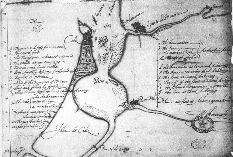
- Sir Francis Drake’s Map of the Attack on Cadiz, 1587. Unknown (author). Plano de Francis Drake en el ataque de Cádiz, en 1587
By 1587, there was fear that King Philip III of Spain was planning an invasion of England. In response to these fears, Queen Elizabeth I of England sent Sir Francis Drake on an expedition to Cadiz, Spain to determine the enemy’s preparations and destroy as much of the ports and ships as possible. Drake and his squadron, including Christopher Newport, succeeded in destroying valuable equipment, provisions, and supplies that rendered a Spanish invasion impossible.[8]

- Portrait of Sir Francis Drake, Marcus Gheeraerts the Younger (1561-1636). Sir Francis Drake after 1590. Oil on canvas, Buckland Abbey
Following this victory, Christopher Newport entered the privateering business. Having both trade and combat experience at sea, he appeared to be a prime candidate. Privateers were persons or warships licensed by the government to attack and destroy enemy trade ships. This was a common tactic to weaken Spain economically in the Anglo-Spanish War both in Europe and across the Atlantic in the Caribbean. Initially, Newport was a master’s mate on the Drake, a ship owned by London merchant John Watt. On the ship roster, his name is listed as “Christopher Newport of Limehouse, Mariner.” The ship sailed along the coast of Spain preying on trade ships. By 1589, Newport became the master of his own ship, Margaret, in a privateering venture funded by several of London’s most powerful merchants.[9]
At 30 years-old, Newport received his first command position on the Little John, part of a fleet of ships owned by merchant John Watt that sailed to the West Indies, presently known as the Caribbean. They set sail from Plymouth, England in March 1590 and arrived in Dominica in late April of that year. The fleet of eight ships prowled the area waiting for the arrival of a Spanish trade squadron. On July 2, while Newport and his fleet were at Hispaniola, fourteen Spanish ships came into view and English ships pursued them. Newport salvaged sugar, ginger, and animal hides from one ship that ran aground in Jamaica.[10]
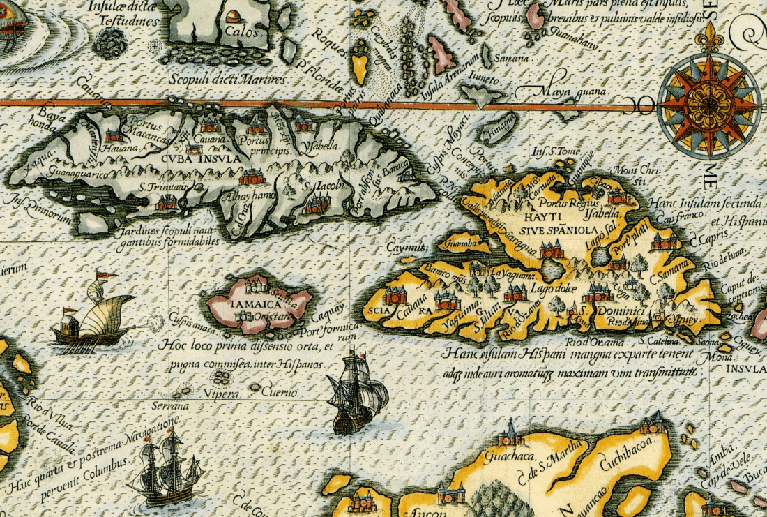
- Theodor de Bry, Map of Florida and the Caribbean from 1594
After this encounter, some ships set off for the Roanoke colony in North Carolina while Newport and others headed for Cuba. Near Havana, the fleet encountered two Spanish treasure ships. Newport’s ship targeted the smaller, weaker one and engaged in a bitter struggle. The English boarded the Spanish ship and suffered heavy losses. Sixteen men were injured; four men, including Newport’s lieutenant, were killed; and Christopher Newport himself had his right arm “stricken off” in battle. The Spanish ship sunk before the English could salvage any cargo. After this disaster, the Little John limped to the Azores on their return to England without any major treasures.[11]
- Major Locations in the 1590 Expedition. Lencer, Caribbean map blank.svg, March 2007. Cropped with text and shapes added by Katherine Warakomski
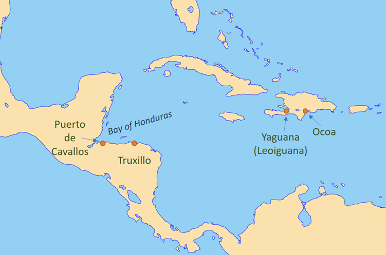
Newport, unfazed by his injury and the loss of his arm, set sail for the Caribbean once again in 1592 and secured his most significant treasure haul. In a venture funded by London merchants, Newport commanded four ships, including his own ship, the Golden Dragon. The fleet was ambitious and adapted the tactics of Sir Francis Drake in landing at and attacking Spanish towns and cities. They successfully sacked and raided the towns of Ocoa and Yaguana on Hispaniola. Next, they set off to the Bay of Honduras where they captured a Spanish ship on the coast of Truxillo and raided the port city, Puerto de Cavallos. When attempting to take Truxillo itself, the Spanish forces repelled them. Later, Newport’s fleet was successful in capturing the Spanish ship Madre de Dios that carried a haul of luxury goods worth half of a million English pounds. This great success encouraged more privateering and Newport remained with this syndicate until 1594.[12]
By 1595, Christopher Newport had risen in the ranks from a common mariner to one of the most experienced and well-known commanders of his time. Between this point and his first voyage to Virginia in 1606, Newport continued privateering activities in the Caribbean. He was recorded to have seized the greatest haul during the entire Anglo-Spanish War, yet there is little other evidence to support this. He continued to command fleets and even became a partner in a privateering venture as the war continued. He later would become a major part of the Virginia Company, the venture that sponsored the settlement at Jamestown.[13]

- Major locations in Captain Newport’s 1590 expedition to the West Indies. Lencer, Caribbean map blank.svg, March 2007. Cropped with text and shapes added by Katherine Warakomski
The Virginia Company
The story of Virginia begins in the bustling city of London, the seat of political and commercial power in England and the headquarters of the Virginia Company. This company was formed by a group of Englishmen – merchants, gentlemen, and noblemen – with the goal of colonizing “Virginia.” At that time, “Virginia” referred to the coast of North America above Spanish Florida, ranging from southern North Carolina to mid-Maine. Virginia was believed to be the land of opportunity for several different ventures: trade, agriculture, and industry.[14]
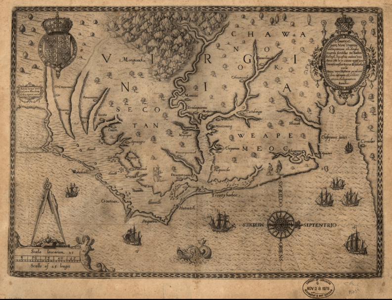
- Map of the coast of “Virginia” from 1590. Depicts the coast of North America from modern Cape Fear, North Carolina to the Chesapeake Bay. In this map, north is oriented to the right rather than the top of the page. John White, Active, Theodor De Bry, and Thomas Harriot. Americæ pars, nunc Virginia dicta: primum ab Anglis inuenta, sumtibus Dn. Walteri Raleigh, Equestris ordinis Viri, Anno Dn̄i. MDLXXXV regni Vero Sereniss. nostræ Reginæ Elisabethæ XXVII, hujus vero Historia peculiari Libro descripta est, additis etiam Indigenarum Iconibus. [Francofurtum ad Mænum: De Brÿ, 1590] Map. Library of Congress
In early 17th century England, there was a theory that a waterway existed in North America that connected the Atlantic Ocean to the Pacific. The Virginia Company was interested in creating a colony at the mouth of this waterway to secure access to the Pacific and subsequently establish trade with China, a goal of England’s since the beginning of the Age of Exploration (though such a waterway does not exist, as discovered by the Lewis and Clark expedition two hundred years later). There had an interest in local trade with the native tribes and the desire to foster good relations with them.[15]
The Company was also interested in the natural resources available in the territory. Agriculturally, the Company was interested in finding a cash crop such as sugar, spices or wine to sell abroad and make a profit. Virginia eventually developed a lucrative cash crop in tobacco. Industrially, there was interest in mining, not only for precious metals like gold, but also copper and iron.[16]

- Portrait of King James I of England, 1606. John de Critz, King James I of England and VI of Scotland. Early 17th-century copy of a circa 1606 original. National Portrait Gallery, United Kingdom
On April 10, 1606, King James I of England signed the First Virginia Charter, giving the Virginia Company “licence to make habitacion, plantacion and to deduce a colonie of sondrie of our people into that parte of America commonly called Virginia.”[17] On December 29, 1606, three ships set sail from London under the command of Christopher Newport—Susan Constant, Godspeed, and Discovery—to make the five-month journey to the New World. To captain the first expedition to England’s new colony was undoubtedly a great honor and demonstrated how highly regarded Christopher Newport was as both a mariner and a leader. This event is so significant to Virginia’s history that it was chosen to be on the state quarter.[18]

- Full-scale reproduction of the Susan Constant located at the Jamestown Settlement living history museum in Virginia. Susan Constant (48784744)
The Jamestown Colony
The first sighting of land was in late April 1607. Newport’s crew spotted what would later be known as Cape Henry, located at the mouth of the Chesapeake Bay (in modern day Virginia Beach). At this point, Christopher Newport allowed the sealed box containing the names of the persons selected by the Virginia Company to govern the new colony to be opened, which included Newport himself by right of office. The Company had ordained that the colonists build a fortified base 100 miles inland of the ocean along a river to protect from possible Spanish attacks. They traveled down the largest river of the Chesapeake Bay, naming it the James River. Along the way, as they interacted with the local natives, Christopher Newport traded trinkets such as bells, sewing pins, and beads in exchange for food. According to John Smith (one of the leaders of the colony as instructed by the Virginia Company), Newport treated the native people with kindness and esteem. On May 14, 1607, the colonists settled on a location for their colony: Jamestown Island. Although only 35 miles from the open sea, they had ordained the location to be defensible and, noted by John Smith, to be “a very fit place for the erecting of a great cittie.”[19]

- See the small triangular shape in the center? That is the only known 17th century depiction of Jamestown in the Zúñiga map, created by Pedro de Zúñiga y de la Cueva for the court of King Philip III of Spain. Unknown. Zuniga map.jpg. 1608. Ministerio de Edicación y Cultura de España, Archivo General de Simancas, MPD, 19, 163
Shortly after landing, settlers began to build their fortress and Christopher Newport formed an exploratory team to search for gold and find a potential passage to China. On June 22, 1607, Newport returned to England, leaving several weeks provisions for the colony. He had returned to England by July, bringing news and samples of Virginia’s natural resources. He described Virginia as rich in copper and reported that he had explored a river “one hundred and fifty miles” long, an exaggerated statement to keep hopes of a passage to China alive. He set sail for Jamestown in October of that year carrying seventy new colonists, including two women and German and Polish manufacturing experts.[20]
In late 1608, after a rough start, Jamestown was beginning to prosper under Smith’s governance and Newport sailed back to England with clapboard, wainscot, and goods made by the colonists. When he arrived in London in January 1609, a second Virginia Charter was in process. Sensational books describing the territory and potential opportunities available piqued public interest in Virginia and English colonies. Furthermore, the joint-stock companies were successful in funding these ventures, as they pooled the resources of many individuals to divide the risk.[21]

- John Smith’s map of Virginia, made into an etching by William Hole.
John Smith and William Hole. Virginia. [London, 1624] Map. Retrieved from the Library of Congress, number 99446115
Shipwrecked
In June 1609, nine ships set sail from Plymouth, England, commanded by Admiral Sir George Somers, one of the founders of the Virginia Company. Included in the fleet was the Sea Venture—the flagship of the Jamestown colony—captained by Vice-Admiral Christopher Newport. On July 24, the fleet encountered a hurricane. William Strachey, aboard the Sea Venture, recorded the experience in detail:
“a dreadful storm and hideous began to blow from out the northeast, which swelling and roaring, as it were, by fits, some hours with more violence than others, at length did beat all light from heaven, which like an hell of darkness turned black upon us…For four and twenty hours the storm in a restless tumult had blown so exceedingly as we could not apprehend in our imaginations any possibility of greater violence…It could not be said to rain. The waters like whole rivers did flood in the air. …What shall I say? — Winds and seas were as mad as fury and rage could make them. For mine own part, I had been in some storms before… Yet all that I had ever suffered gathered together might not hold comparison with this.” –William Strachey, A true repertory on the wracke…July 15, 1610
The storm severely battered the ship, but fortunately, there were no casualties. A leak caused the ship to fill with water that the passengers worked to bail out. To lighten the ship, they cut down the main mast threw cargo overboard. After three days at sea, Admiral Somers spotted land, now known as Bermuda. Neither Newport nor Somers had happened upon these islands before. With no other option, the passengers of the Sea Venture came ashore.[22]
Due to the ship’s considerable damage, the passengers of the Sea Venture were stranded on the tropical island for nine months, until they could construct a sea-worthy vessel to take them to Virginia. During their time stranded on the island, the passengers utilized the island’s natural resources to stay alive. The island had lush flora and fauna that they used for food, including sea turtles, which Strachey described as a “toothsome (some say) wholesome meat.”[23] They ultimately built two boats, the Deliverance and Patience, made from cedar from the island and salvaged materials from the Sea Venture, before setting sail for Jamestown once again.[24]

- Image of a Bermuda cedar tree and the island’s landscape. The shipwrecked settlers used the wood from these trees to help construct boats to continue their voyage to Virginia. Aodhdubh. Juvenile Bermuda Cedar at Ferry Reach.jpg. 17 October 2007
In the months between July 1609 and May 1610, Jamestown had undergone a severe hardship known as “The Starving Time.”[25] Newport and the rest of the shipwrecked passengers approached Jamestown in a ragged state. “Viewing the fort,” Strachey recorded, “we found the palisades torn down, the ports open, the gates from off the hinges, and empty houses (which owners’ death had taken from them) rent up and burned, rather than the dwellers would step into the woods a stone’s cast off from them to fetch other firewood. And, it is true, the Indian killed as fast without, if our men stirred but beyond the bounds of their blockhouse, as famine and pestilence did within…”[26] The Bermuda ships brought more settlers, including women, and very little supplies. The remaining colonists at Jamestown decided to abandon the fort and return to England, seeing survival as impossible. However, in a stroke of luck, Governor De La Warre and his fleet arrived as the colonists were leaving, bringing fresh supplies and new hope to the colony. They returned to Jamestown and began to recover from the difficult winter. Yet many trials awaited them, including the Anglo-Powhatan Wars, as natives fought to preserve their land and sovereignty.[27]
Captain Newport’s Legacy
Christopher Newport served the Virginia Company and Jamestown until 1611, and joined the East India Company in 1612. Although an old man by the era’s standards – fifty-two years old – he was an experienced and talented mariner. For his excellent work and speedy voyages, he was rewarded with 50 jacobuses, equivalent to 1,250 shillings or 62.5 pounds sterling (equal to $15,550.25 in 2017 American dollars).[28] For five years, Newport remained in service to the East India Company, travelling to Banten, Java—a major trade hub in Southeast Asia in the early 17th century (today known as the largest island of Indonesia). On his third voyage to Banten on August 15, 1617, Christopher Newport passed away from unknown causes.[29]
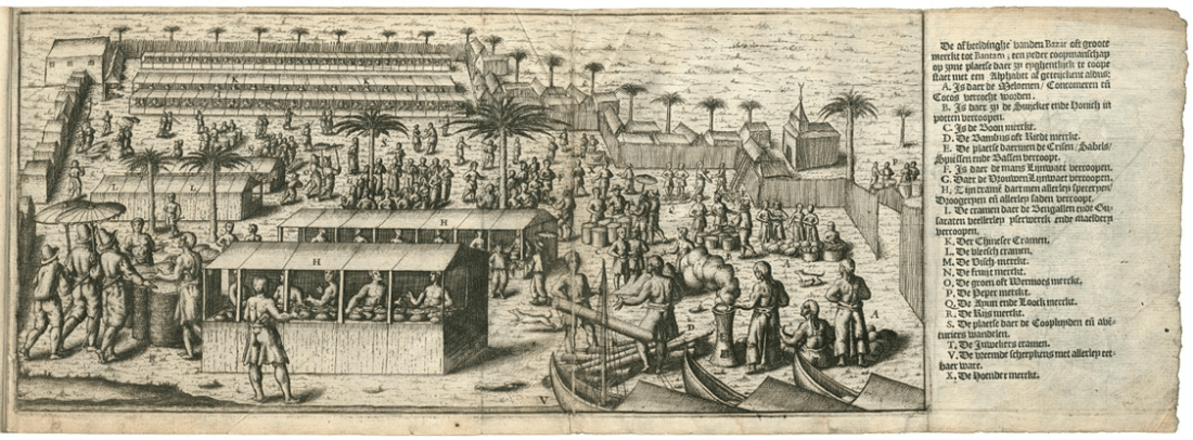
- 1598 Depiction of the Marketplace in Bantam, Java
 In his fifty-seven years, Christopher Newport lived an extraordinary life of significance. He lived through an age of innovative maritime technology, where science and mathematics were utilized to help people understand the world around them. He was a part of shifting balance of power in the European world as a privateer in the Anglo-Spanish War. Newport witnessed the birth of globalization and world trade that our modern way of life is based on today. Christopher Newport’s legacy is that he stewarded England’s first successful, permanent North American colony and sailed across the Atlantic multiple times to keep Jamestown supplied, and showed strong leadership when faced with difficult challenges, and persevered.
For more information about the history of maritime exploration, visit http://exploration.marinersmuseum.org/
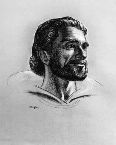
Images of Christopher Newport at top and bottom of exhibition from modern portrait sketch of Christopher Newport by Allan D. Jones, Jr., Courtesy of The Mariners’ Museum, and Captain Christopher Newport, Admiral of Virginia, book cover by A. Bryant Nichols Jr., respectively.
Further Reading
“Back Staff,” The Ages of Exploration, The Mariners’ Museum and Park. Accessed August 16, 2017. http://exploration.marinersmuseum.org/object/back-staff/
The Complete Works of Captain John Smith (1580 – 1631) in Three Volumes, edited by Philip L. Barbour, volume 1. Chapel Hill, NC: University of North Carolina Press, 1986.
“The First Virginia Charter”. University of Oklahoma College of Law. Accessed August 15, 2017. http://www.law.ou.edu/ushistory/vchart1.shtml
“Traverse Board,” The Ages of Exploration, The Mariners’ Museum and Park. Accessed August 16, 2017. http://exploration.marinersmuseum.org/object/traverse-board/
Andrews, K.R. “Christopher Newport of Limehouse, Mariner” The William and Mary Quarterly 11, no. 1, (January 1954): 28-41.
Ash, Eric H. “Navigation Techniques and Practice in the Renaissance” in Cartography in the European Renaissance ed. David Woodward, vol. 3 of The University of Chicago History of Cartography. Chicago, IL: University of Chicago Press, 2007: 509-527.
Barrow, John. The Life, Voyages, and Exploits of Sir Francis Drake: With Numerous Original Letters from Him and the Lord High Admiral to the Queen and Great Officers of State. London, UK: John Murray of Albemarle Street, 1844.
Craven, Wesley Frank. The Virginia Company of London, 1606-1624. Williamsburg, VA: Virginia 350th Anniversary Celebration Corporation, 1957.
Elliott, J.H. Empires of the Atlantic World: Britain and Spain in America 1492-1830. New Haven, CT: Yale University Press, 2006.
Friel, Ian. “Guns, Gales, and God: Elizabeth I’s ‘Merchant Navy’,” History Today 60, no. 1 (January 2010): 45-51.
Kelso, William M. Jamestown: The Buried Truth. Charlottesville, VA: University of Virginia Press, 2006.
Love, Ronald S. Maritime Exploration in the Age of Discovery, 1415-1800. Westport, CT: Greenwood Press, 2006.
Nichols, A. Bryant Jr. Captain Christopher Newport, Admiral of Virginia. Sea Venture, LLC, 2007.
Nye, Eric W., Pounds Sterling to Dollars: Historical Conversion of Currency. Accessed Wednesday, August 16, 2017. http://www.uwyo.edu/numimage/currency.htm.
Quinn, David B. “Christopher Newport in 1590” The North Carolina Historical Review 29, no. 3, (July 1952): 305-316.
Rose, Susan. “Mathematics and the Art of Navigation: The Advance of Scientific Seamanship in Elizabethan England” Transactions of the Royal Historical Society 14 (2004): 175-184.
Strachey, William. A true repertory on the wracke, and redemption of Sir THOMAS GATES knights; upon, and form the Ilands of the Bermudas; his coming to Virginia, and the estate of that Colonie then, and after, under the government of the Lord LA WARRE, July 15, 1610. Virtual Jamestown. Retrieved August 16, 2017 from virtualjamestown.org
Ueda, Kaoru et al. “Consumption of Chinese and European Ceramics at the Sultanate of Banten, Java, Indonesia from the Seventeenth to the Early Nineteenth Century: Material Culture of Early Globalism,” in Early Navigation in the Asia-Pacific Region: a Maritime Archaeological Perspective, edited by Channing Wu. Singapore: Singer Science+Business Media, 2016: 225-240.
Notes
[1] K.R. Andrews, “Christopher Newport of Limehouse, Mariner” The William and Mary Quarterly 11, no. 1 (January 1954): 28-29; J.H. Elliott, Empires of the Atlantic World: Britain and Spain in America 1492-1830 (New Haven, CT: Yale University Press, 2006), 8.
[2] Ronald S. Love, Maritime Exploration in the Age of Discovery, 1415-1800 (Westport, CT: Greenwood Press, 2006), 10, 20-21.
[3] Susan Rose, “Mathematics and the Art of Navigation: The Advance of Scientific Seamanship in Elizabethan England” Transactions of the Royal Historical Society 14 (2004): 175-176.
[4] Eric H. Ash, “Navigation Techniques and Practice in the Renaissance” in Cartography in the European Renaissance ed. David Woodward, vol. 3 of The University of Chicago History of Cartography (Chicago, IL: University of Chicago Press, 2007), 509, 510, 514-515, 517, 518.
[5] Rose, “Mathematics,” 176-177; Ash, “Navigation Techniques,” 522-523.
[6] See The Life, Voyages, and Exploits of Sir Francis Drake: With Numerous Original Letters From Him And The Lord High Admiral To The Queen And Great Officers Of State John Barrow, Esq, F.S.A, 1844.
[7] Ian Friel, “Guns, Gales, and God: Elizabeth I’s ‘Merchant Navy’,” History Today 60, no. 1 (January 2010): 46.
[8] John Barrow, The Life, Voyages, and Exploits of Sir Francis Drake: With Numerous Original Letters from Him and the Lord High Admiral to the Queen and Great Officers of State, (London, UK: John Murray of Albemarle Street, 1844), 96, 98, 113.
[9] Andrews, “Christopher Newport,” 29-30; Friel, “Guns, Gales, and God,” 49.
[10] Andrews, “Christopher Newport,” 29-30; David B. Quinn, “Christopher Newport in 1590” The North Carolina Historical Review 29, no. 3, (July 1952): 307-309.
[11] Quinn, “Newport in 1590,” 311-313.
[12] Andrews, “Christopher Newport,” 31-33.
[13] Andrews, “Christopher Newport,” 33-40.
[14] Wesley Frank Craven, The Virginia Company of London, 1606-1624 (Williamsburg, VA: Virginia 350th Anniversary Celebration Corporation, 1957), 1, 2-3, 12.
[15] Craven, The Virginia Company, 9-12.
[16] Craven, The Virginia Company, 11, 12.
[17] “The First Virginia Charter”, (April 10, 1606), University of Oklahoma College of Law, http://www.law.ou.edu/ushistory/vchart1.shtml, accessed August 15, 2017.
[18] Craven, The Virginia Company, 12-13.
[19] William M. Kelso, Jamestown: The Buried Truth (Charlottesville, VA: University of Virginia Press, 2006), 12, 14; The Complete Works of Captain John Smith (1580 – 1631) in Three Volumes, ed. Philip L. Barbour, volume 1, (Chapel Hill, NC: University of North Carolina Press, 1986), 28.
[20] Barbour, Complete Works of Captain John Smith, 32; Craven, The Virginia Company, 13.
[21] Kelso, Jamestown, 19; Craven, The Virginia Company, 15-16.
[22] William Strachey, A true repertory on the wracke, and redemption of Sir THOMAS GATES knights; upon, and form the Ilands of the Bermudas; his coming to Virginia, and the estate of that Colonie then, and after, under the government of the Lord LA WARRE, July 15, 1610. VirtualJamestown.org, 1-2 (quote), 5.
[23] Strachey, A true repertory, 12.
[24] Strachey, A true repertory, 21.
[25] Strachey, A true repertory, 23.
[26] Strachey, A true repertory, 23.
[27] Kelso, Jamestown, 39-40.
[28] Andrews, “Christopher Newport,” 40, 41; Eric W. Nye, Pounds Sterling to Dollars: Historical Conversion of Currency, accessed Wednesday, August 16, 2017, http://www.uwyo.edu/numimage/currency.htm.
[29] Kaoru Ueda et al. “Consumption of Chinese and European Ceramics at the Sultanate of Banten, Java, Indonesia from the Seventeenth to the Early Nineteenth Century: Material Culture of Early Globalism,” in Early Navigation in the Asia-Pacific Region: a Maritime Archaeological Perspective, ed. Channing Wu, (Singapore: Singer Science+Business Media, 2016), 226; Andrews, “Christopher Newport,” 41.
